
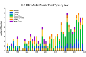
Climate Indicators
The North Carolina Institute for Climate Studies (NCICS) hosts a platform that delivers key climate information highlighting the Program’s data and providing technical input for reports such as the National Climate Assessment. NEMAC works with the NCICS team to develop static and dynamic graphics that help communicate these key climate messages.
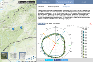
Landscape dynamics assessment tool (LanDAT)
The Landscape Dynamics Assessment Tool (LanDAT) is used to assess landscape dynamics based on satellite-observed vegetation change. NEMAC, together with the U.S. Forest Service’s Eastern Forest Environmental Threat Assessment Center, developed LanDAT to assist planners and resource managers in understanding and incorporating landscape resilience and vulnerability into project planning.
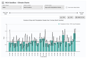
NCA Sandbox
NEMAC partners with NOAA’s Technical Support Unit to create the NCA Sandbox, a tool to help authors create figures for their respective chapters in the National Climate Assessment.