

The Climate Explorer
The Climate Explorer is an interactive tool providing graphs, maps, and downloadable data of observed and projected climate conditions for every county in all 50 states and U. S. territories. The climate projection graphs for temperature, precipitation, and related climate variables include ranges of climate model results for two possible futures—one in which humans make a significant attempt to reduce global emissions of heat-trapping gases and one in which the rate of global emissions continues rising through 2100. NEMAC co-developed the Climate Explorer with our partner Fernleaf and a group of federal science agencies led by NOAA’s Climate Program Office.
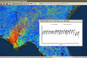
Forest Change Assessment Viewer (FCAV)
The Forest Change Assessment Viewer (FCAV) is an interactive tool that uses high-frequency, moderate-resolution satellite data to provide near real-time change maps of the continental U.S. to understand forest change. NEMAC developed and maintains FCAV in partnership with the U.S. Forest Service’s Eastern Forest Environmental Threat Assessment Center.
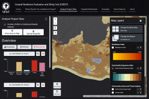
Coastal Resilience Evaluation and Siting Tool (CREST)
The Coastal Resilience Evaluation and Siting Tool (CREST) is an online, interactive platform to access the Regional Coastal Resilience Assessments results developed by the National Fish and Wildlife Foundation (NFWF) in partnership with NOAA, NEMAC, and in consultation with the U.S. Army Corps of Engineers and NatureServe. With CREST, users can interact with Assessment data to identify potential areas for nature-based solutions for coastal resilience that also consider benefits for human communities and fish and wildlife habitats.